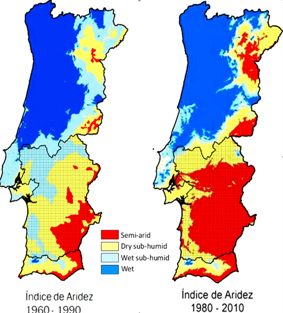
Aridity index evolution (adapted from Lúcio de Rósario, PFNCNUCD 2011)
The aim of the PIEZAGRO project is to improve the scientific knowledge on the relationships between the semi-arid vegetation of the Mediterranean area and its access to groundwater sources. In particular we intend to evaluate, for the first time to our knowledge, the risks associated to the alteration of the water table level in response to climate change on the depending vegetation and associate ecosystems in the Mediterranean region.
The proposal focuses on the fate of groundwater dependent ecosystems (GDEs) and rainfed deep-rooted agroforestry species in the Alentejo region of South Portugal. The project intends to delimit the most vulnerable areas to desertification with a high confidence level and provide mitigation solutions for the geographical area classified by priority.
Divided in 5 tasks, the project seeks to accurately identify geographical areas of the region that are most threaten by the combination of climate change and water table drawdown, by
1/ establishing the potential distribution of ground dependent species and their respective degree of dependency to groundwater source
2/ modeling the relationship between water table level and tree productivity
3/ predicting the impact of future climate conditions and water demand on the water table level
4/ integrating information to identify priority areas for water management adaptations.
The present proposal present a strong advantage in this kind of studies, as it relies exclusively on pre-existing available reliable datasets, reducing considerably the estimated costs and risk of failure. It also relies on an innovative approach gathering state-of-the-art methodologies which have been successfully used in former studies around the globe. We are thus extremely confident about the expected outcomes.
The Project Research Team present a solid scientific and technical expertise and has experience in sharing their expertise in several fields, ranging from Ecophysiology, Geophysics, Meteorology, GIS, Remote sensing, and Hydrological Modeling and belonging to 2 different institutions from Lisbon University (IDL and IST) with high scientific level in the research domains mentioned in the present proposal. Additionally the project team is counting with the consulting expertise of two scientists from 2 well known Portuguese Institution in the field of Dendrochronology, such as UTAD and Coimbra University.
Using public available data, the PI will develop a GIS-based methodology that will be combined with the climate characteristics of the region to build a screening tool to identify critical geographical areas of Alentejo displaying a high potential to host a significant number of GDEs (task 1.1).
Cathy Kurz-Besson (PI) will coordinate the project and lead most of the tasks (1, 2, 5, 6). She worked in the forestry department of the Instituto Superior de Agronomia (ISA) for 10 years. Through past and ongoing European (EUPORIAS- , MIND- EVK2-CT-2002-00158, NETCARB- HPRN-CT-1999-00059) and National projects (QSECA – PTDC/AAG-GLO/4155, ongoing, POCI/AGR/59152, PTDC/AGR-CFL/099614/2008, PIDDAC 216/200, POCI/CLI/60006/2004, PTDC/AGR-CFL/099614/2008), the PI specialized on the adaptations of the Mediterranean vegetation to aridity and recurrent droughts. She is mostly interested in the access of deep-rooted plants to groundwater. She was recently successfully formed in GIS methods (QGIS 2.6) and spatiotemporal analyses. Her large collaboration network in the field of Plant Ecology will provide the access to any relevant GIS ecological information available in Portugal or abroad. During the last 6 years she has working at Climate Change group of IDL, enlarging her scientific network and promoting the exchange of up-to-date observations and simulations of the past, present and future climate in the ecological community. At the moment she is part of the team of a national FCT project QSECA (PTDC/AAG-GLO/4155/2012) assessing the impact of extreme drought events on tree growth using drought indices and dendrochronolies obtained over Portugal.
Her team colleague, Rita Cardoso (IDL) is a mesoscale Meteorological expert involved in several European climatic consortiums (EURO-CORDEX, EC-Earth, ENSEMBLES). The alteration of precipitation patterns due to global changes are one of her main scientific interests. The project will strongly benefit from Rita’s current experience in the EUPORIAS European Project (FP7-ENV-2012) in linking dendrochronology to the past evolution of the water table level in Portugal (task 3). She will also lead task 4 by bringing up-to-date simulations of future climate conditions based on scenario RCP 8.5 for Portugal with a high resolution (9km).
Remote sensing methodologies will be applied on geographical areas suspected to host GDEs to identify vegetation traits that exhibit the physiological footprint of groundwater dependency (Task 1.2). To do so previous methodologies provided by Eamus et al. (2006) and Gou et al.(2015) will be adapted to the Portuguese territory characteristics, the available GIS and Remote Sensing data sources.
Célia Gouveia (IDL) is an expert in remote sensing and related vegetation and drought stress indexes. She possesses the geospatial analyses knowhow that will allow the accurate digital definition of GDEs footprint on which the success of the project relies. She has a strong scientific background and training with any relevant satellite databases. She will use the Landsat multispectral land cover, CORINE vegetation cover and MODIS Enhanced Vegetation Index EVI datasets and build the deterministic and stochastic methods to extract the most relevant digital information for the project.
Tree ring information provides a precious tool to link GDE productivity to the variability of the piezometric level. There are many times-series of dendrochronology available in Portugal. José Lousada, consultant on task 3, is the Coordinator of the Forest Products Laboratory of the Forestry Department of the University of Trás-os-Montes e Alto Douro (UTAD). He is an expert of wood quality and dendrochronology. From several past projects, he collected dendrochronological sequences of six tree species distributed all over Portugal, including Cork oak and Maritime pine. He already shared tree ring information with the PI through the project (PTDC/AGR-CFL/099614/2008) to link recent climate changes to wood growth and quality. The yet unpublished results will provide precious clues for the present proposal. In Coimbra University, Cristina Nabais previously analysed dendrochronological series from Holm oak and Stone pine. A former collaboration between our investigation group and her team within the national project MEDIATIC –PTDC/AAC-CLI/103361/2008 will guarantee the access to the dendrochronological information needed to acheive task 3.
Dendrochronological series will be compared to piezometric time-series to link deep-rooted tree species growth to the fluctuation of the water table level. This has been successfully attempted by Pilas et al. (2003) on Pedonculate oak in Croatia. Whenever no significant signal of the water table oscillations can be found in tree ring width, then relationships with climatic multi-scalar drought indexes such as SPEI and SPI will be investigated. This has already been tested with success on Maritime pine (Kurz-Besson et al. in preparation). Those indexes will give a precious information on the effect of extreme soil water deficits on the growth of deep-rooted species.
Piezometric time-series will be retrieved from a national groundwater monitoring network consisting in 884 stations spread along Portugal, from which 805 are recording the water table level on a monthly basis. Some of the series are long enough to investigate trend evolutions (Ribeiro & Vega da Cunha, 2010). Datasets will be provided by João Nascimento from the Instituto Superior Técnico (IST). He is an expert in the fields of Water Resources Engineering, soil hydrological modeling and groundwater management. He estimated the evolution of the piezometric level in response to different climate change scenarios in the Aveiro region of Portugal (Nascimento et al. 2004). He will therefore lead and provide the largest scientific contribution in task 4 devoted to the modeling of groundwater depth in response to climate change in a selected watershed of the Alentejo region.
Task 5 will integrate the results of the four previous tasks, and thus will rely on the scientific contributions of each member involved in the project. The outcomes and innovations expected from the projects are
1/ The map of geographical areas with the highest probability to host groundwater dependent ecosystems and phreatophyte species (tasks 1-2);
2/ An ecohydrological model linking deep-rooted tree growth to the depth of groundwater table or deep soil water deficit (task 3)
3/ A hydrological model able to predict the evolution of the water table level in response to climate changes (task 4)
4/ A sensivity map displaying the vulnerability index of GDEs from the present to the future, in response to the evolution of climate conditions and water table level, within the 21st century and according to the most probable climate change scenario (RCP 8.5).
Those outcomes will provide a useful innovative tool for stakeholders and policy makers to select top-priority areas to be monitored, protected or submitted to new management plans to mitigate expected negative impacts. Outcomes are also expected to provide essential information to be implemented into hydrological and forest productivity models. For example, mapped phreatophytes were found to be useful for validating a ground water flow model that included ground water discharge to the surface (Batelaan et al. 2003).
Outcomes will also be critical to ecological managements in the Alentejo region and will provide reproducible methodologies to be applied to any semi-arid environment of the Mediterranean basin.